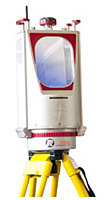
VZ-4000 3D Terrestrial Laser Scanners with Online Waveform Processing
Terrestrial Scanners
This 3D VZ-Line Laser Scanner offers superior and unrivaled long range measurement performance of up to 4000 m reflectorlessly while still maintaining completely eye safe operation (Laser Class 1).
RIEGL's unique V-Line® technology is based on echo digitization and online waveform processing and is the key to enabling such extreme long range measurements. The VZ-4000 operates even in poor visibility and demanding multi target situations caused by dust, haze, rain, snow, etc. which are frequently found in difficult environments such as mine sites.
Main Features:
- Very long range up to 4000 m
- Eye safe operation in Laser Class 1
- Wide field of view, 60° x 360°
- High speed data acquisition up to 222,000 meas./sec
- High accuracy, high precision ranging based on echo digitization and online waveform processing
- Multiple target capability - unlimited number of targets
- Optional waveform data output
- Built-in calibrated digital camera
- On-board inclination sensors
- Integrated L1 GPS receiver with antenna
- Integrated compass
- Built-in SSD data storage media
- Compact and rugged design
- Advanced camera options
- 300 kHz laser pulse repetition rate
- 15 mm accuracy
- 10 mm precision
- 4000 m range
- 5 m minimum range
- Field of view: Vertical (Line) Scan: total 60° (+30° / -30°) | Horizontal (Frame) Scan: 360°
- Eye safe operation at Laser Class 1
- Main dimensions: 248 mm (l) x 226 mm (w) x 450 mm (h)
- Weight: 14.5 kg
Main Applications:
- Topography & Mining
- Monitoring
- Civil Engineering
- Archaeology & Cultural Heritage
Unit of Measure


