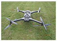
The RIEGL RiCOPTER is the first unmanned aircraft system developed and manufactured by a leading provider of laser scanners and scanning systems and offers the first-class technique and system efficiency RIEGL is well known for in commercial civil surveying market.
The robust and reliable airborne scanner carrying platform provides full mechanical and electrical integration of sensor system components into aircraft fuselage. The extremely lightweight carbon fiber main frame, foldable propellermore
The RIEGL RiCOPTER is the first unmanned aircraft system developed and manufactured by a leading provider of laser scanners and scanning systems and offers the first-class technique and system efficiency RIEGL is well known for in commercial civil surveying market.
The robust and reliable airborne scanner carrying platform provides full mechanical and electrical integration of sensor system components into aircraft fuselage. The extremely lightweight carbon fiber main frame, foldable propeller arrier arms, and shock-absorbing undercarriage enable stable flight, safe landings and handy transportation. The flight characteristics of the X-8 array octocopter are smooth and stable in hovering positions as well as in demanding flight maneuvers under challenging conditions.
The RiCOPTER can be equipped with different sensors up to an overall maximum payload of 16 kg (sensors and power supply).
For surveying missions, the RiCOPTER is equipped with the RIEGL VUX-SYS for RiCOPTER, comprising the VUX-1UAV LiDAR sensor, a IMU/GNSS unit, a control unit, and up to four high-resolution cameras.
Main Features:
- High performance X-8 array foldable octocopter
- Payload weight 16 kg (sensors and power supply)
- Maximum Take-off Mass (MTOM) <25 kg
- Flight endurance with maximum load 30 minutes
- Operating flight altitude AGL of > 500 ft (operational limits for civil unmanned aircraft according to national regulations to be observed)
- Cushioned landing legs and shock-absorbing undercarriage for stable flights and save landings
- Foldable propeller carrier arms, integrated carrying handle, and special box for transportation
Main Applications:
- Precision Agriculture
- Topography in Open-Cast Mining
- Terrain and Canyon Mapping
- Surveying of Urban Environments
- Archaeology and Cultural Heritage Documentation
- Construction-Site Monitoring
- Corridor Mapping:
- Power Line
- Railway Track
- Pipeline Inspection


