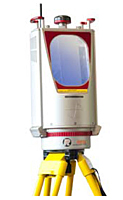
VZ-6000 3D Ultra Long-Range Terrestrial Laser Scanners with Online Waveform Processing
Terrestrial Scanners
The new high speed, high resolution terrestrial 3D Laser Scanner VZ-6000 offers an extremely long measurement range of more than 6000 m for topographic (static) applications. Being the Laser Class 3B companion to the VZ-4000, it is, due to its laser wavelength, exceptionally well suited for measuring snowy and icy terrain in glacier mapping and monitoring applications in mountainous regions.
The RIEGL VZ-6000 is compatible with the well-proven RIEGL software package RiSCAN PRO for terrestrial laser scanning, RIEGL's interface library RiVLib, as well as the workflow-optimizing software packages RiMONITOR and RiMINING. The software plugin RiMTA-3D provides automatic assignment of the correct MTA zones in multiple time around processing.
Main Features:
- Ultra long range up to 6000 m
- Laser Class 3B
- Wide field of view, 60° x 360°
- High speed data acquisition up to 222,000 meas./sec
- High accuracy, high precision ranging based on echo digitization and online waveform processing
- Multiple target capability - unlimited number of targets
- Multiple time around processing
- Optional waveform data output
- Built-in calibrated digital camera
- On-board inclination sensors
- Integrated L1 GPS receiver with antenna
- Integrated compass
- Built-in SSD data storage media
- Compact and rugged design
- Advanced camera options
- Up to 222,000 measurements/sec
- 15 mm accuracy
- 10 mm precision
- 6000 m range
- 5 m minimum range
- Field of view: 60° vertical / 360° horizontal
- Laser Class 3B
- Main dimensions: 248 mm (l) x 226 mm (w) x 450 mm (h)
- Weight: approx. 14.5 kg
Main Applications:
- Glacier & Snowfield Mapping
- Topography & Mining
- Monitoring
- Civil Engineering
- Archaeology & Cultural Heritage
Unit of Measure


