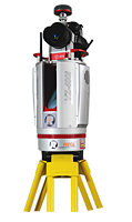
The RIEGL VZ-400i is a 3D Laser Scanning System which combines an innovative new processing architecture, internet connectivity, and a suite of MEMS sensors with RIEGL’s latest Laser Scanning Engine technology.
This real-time data flow is enabled through dual processing platforms; a dedicated processing system for data acquisition, waveform processing and system operations, and a second processing platform which enables real-time data registration, georeferencing, filtering and analysis to be executed simultaneously. The VZ-400i harnesses this power by streaming it in real-time via the integrated 3G/4G/LTE modem, WiFi, Bluetooth, and Ethernet communications hardware.
With its integrated gyroscope, accelerometer, compass and barometer, the VZ-400i’s 1200kHz pulse repetition rate can be fully utilized in nearly any environment and orientation. The system enables an incredible range of flexibility by providing support for numerous external peripherals and accessories via its integrated USB Ports and stable mounting points.
Main Features:
- New, innovative processing architecture for data acquisition and simultaneous geo-referencing, filtering and analysis in real-time
- Cloud connectivity via Wi-Fi and 4G LTE
- High laser pulse repetition rate of up to 1.2 MHz
- Eye safe operation at Laser Class 1
- Wide field of view, 100°x360°
- High speed data acquisition up to 500,000 measurements/sec
- Range up to 800 m, accuracy 5 mm
- High accuracy, high precision ranging based on echo digitization, online waveform processing, and multiple-time-around processing
- Multiple target capability for an unlimited number of target echoes
- Optional full waveform data output
- User friendly touchscreen interface
- MEMS IMU for pose estimation
- 1.2 MHz laser pulse repitition rate
- 5 mm accuracy
- 3 mm precision
- 800 m range
- 1.5 m minimum range
- Field of view: 100° vertical / 360° horizontal
- Eye safe operation at Laser Class 1
- Main dimensions: 260 mm (w) x 308 mm (h)
- Weight: 9.7 kg
Main Applications:
- Transportation
- Surveying
- Architecture & Facade Measurements
- As-Built Surveying
- Archaeology & Cultural Heritage
- City Modeling
- Tunnel Surveying
- Civil Engineering
- Forestry
- Monitoring
- Research
- Topography


